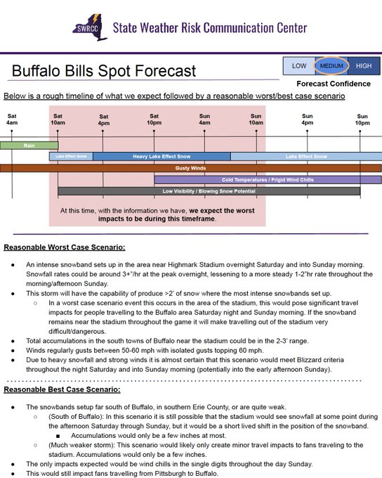
The State Weather Risk Communication Center is a partnership between UAlbany and the New York State Division of Homeland Security and Emergency Services.
Below is a radar animation from noon to 4PM today, with the
@BuffaloBills
stadium circled in orange.
Note how stationary this intense lake effect band was during this time. If the game were played today, it would have been dangerous for attendees and a treacherous commute.
One of our responsibilities is crafting detailed "spot forecasts" for important situations.
The
@BuffaloBills
playoff game on Sunday is an example. While the forecast isn't set in stone, we consider both weather & non-weather factors. Continue to check your local
@NWS
forecast.
Hello New York! Welcome to the State Weather Risk Communication Center, or SWRCC for short. We're thrilled to be here at
@ualbany
.
While we have much to share (soon), we'd like to acknowledge the support of
@GovKathyHochul
and thank the
@TODAYshow
for helping us launch.
New York has launched a first-of-its-kind high-tech center to help track extreme weather and quickly respond to New Yorkersโ needs on the ground.
I had the privilege of showing Americaโs weatherman,
@alroker
, the incredible work being done at
@ualbany
to keep New Yorkers safe!
๐จ We're excited to post our first set of job announcements! These are for four total positions in operational meteorology. All positions come with excellent state benefits.
First, we are hiring 3 entry-level meteorology positions. Application info here:
The
@nysmesonet
operates a dozen weather stations along
@NYSThruway
exits across western NY, including at the Dunkirk exit.
At the time this occurred the wind at 10 feet was gusting to 50 mph, perpendicular to the Thruway. Since then, it's hit a remarkable 57.3 mph. Drive smart!
THIS is why there is an empty truck ban on the Thruway. An empty tractor trailer was blown over on I-90 westbound between exit 59 (Dunkirk) and exit 60 (Westfield) around 10:45 this morning, blocking all lanes.
We're a bit late to this, but we're happy to announce that our State Weather Risk Communication Center at
@ualbany
is once again in
@GovKathyHochul
's budget, released last month. In fact, we're proud to be one of the budget "highlights" - more to come!
Here's an example of the eclipse briefings we've been creating: each briefing has consisted of a weather summary page followed by an in-depth briefing for a variety of key locations. These pages go in to greater detail - sometimes with the types of clouds that may be experienced.
As we get later into winter, human-made snowfall observations (the best kind!) often get less common.
The map on the left shows human measurements for this storm, which show 10" in the
#Catskills
. Thankfully, automated
@nysmesonet
reports can nicely fill in the gaps (right).
One of our priorities this past week was creating a functional operations center. We're doing this by transforming a large
@ualbany
graduate student office.
We removed cubbies to make room for monitors. After some touch-up work, the room is all painted and ready for equipment!
The SWRCC has also been opening "presents" this past week. As we start up, we've ordered office items such as laptops, monitors, printers, and a touchscreen video-conference monitor so that we're ready to go once we've filled the below job postings. Plus, some signage is here!
๐จ We're excited to post our first set of job announcements! These are for four total positions in operational meteorology. All positions come with excellent state benefits.
First, we are hiring 3 entry-level meteorology positions. Application info here:
This nice freezing rain accumulation graphic was made today by SWRCC intern Jack Conklin! Jack is one of six undergraduate interns this semester in either meteorology or emergency management disciplines.
Here is a map of ice accumulation reports from last night through this morning. The highest report was from Morristown NY, of 0.5 inches of ice! More freezing rain is expected tonight which can cause more problems and possible power outages.
#nywx
#nny
Stop us if you've heard this before: western New York is seeing a significant lake effect event. Heavy snow has instigated travel bans and road closures.
Here's an animation of the radar for the Buffalo area since 7PM.
@nysmesonet
sites in the area suggest up to 5"/h rates.
The Skyway in Buffalo is closed to traffic and many towns in Erie County have a complete travel ban. Certain areas of the city of Buffalo are also under a travel ban. Conditions are expected to deteriorate throughout the day. Stay home and stay safe.
A slow-moving heavy band of snowfall in the Hudson Valley has produced 5-7" of snow over the past 3 hours, according to the
@nysmesonet
. The ๐ฅ, ๐ฉ, and ๐ช boxes highlight sites that have reported believable 3.5"/h peak snowfall rates. This band will slowly move northeastward.
It's very windy out there! This is a map of peak wind gusts across New York as of 8PM, courtesy the
@nysmesonet
. All locations at or above 58 mph have already verified NWS High Wind Warnings. Impressively, a believable 72 mph wind gust has been observed near Ticonderoga.
High Wind Warning was expanded to include the Capital District, northern and central Taconics and the Berkshires. The High Wind Warning and Wind Advisory are in effect through early Thursday morning. Gusts up to 60 mph expected in the warning.
The
@NWSWPC
has issued a large moderate risk for excessive rainfall for the Hudson Valley Tuesday-Wednesday, because there's -
โ 3" of rain in the
@NWS
forecast
โ 12-18" of snowfall this weekend, via spotter reports
โ Up to 10" of precipitation in the 30 days, via
@nysmesonet
Ok, so we can't forecast earthquakes at the NY SWRCC, but we do assist with other planetary phenomenon.
Did you know that aside from doing briefings on hazardous weather, we also create detailed eclipse briefings? Here's today's summary page for eclipse weather in NY. ๐๐๐
We are also hiring 1 lead meteorologist position. This position would be expected to supervise the 3 entry level positions and provide some on-the-job mentoring. Demonstrated experience is required for this position.
Application info here:
If you're curious when the heaviest snow will occur today, this hour-by-hour plot of possible snowfall has your answer. Models predict that late afternoon through midnight tonight is likely to have 1"/h snowfall rates (or more) for much of central and eastern NY.
Honored to have
@GovKathyHochul
recognize our work assisting the state during this storm. We look forward to many more contributions as we continue to grow our staff!
Read/hear her remarks right at the start of her interview here:
Big thanks to the
@NYSDOT
for welcoming us on their podcast! It was great to talk about the ways they go about preparing for big weather events, and how the SWRCC can help along the way.
On the latest episode of NYSDOTโs podcast, find out how our partnership with the first-of-its-kind NYS Weather Risk Communication Center (SWRCC) began and how itโs helping NYSDOT be better prepared with whatever Mother Nature has in store.
Listen Now at:
If you're a spring-lover, it's hard not to love these 4PM temperatures (courtesy of the
@nysmesonet
). Temperatures near 70F in western NY have broken several records at long-running climate stations, via
@NWSBUFFALO
.
๐ก๏ธ Buffalo and Watertown broke their record highs this morning, and since then all 3 of our climate sites managed to reach record breaking high temperatures for March 4th.
#NYwx
@jjrennie
@IrishEagle
@RyanBretonWX
@BeauDodson
Yes, that's why we're here in NY! What seems easily interpreted by meteorologists can be difficult for non-experts. A tiny example: sometimes, a forecast of 3" rain means 2.5-3.5" (stratiform) while other times it means 0-9" (convective, like NYC on Sep 29th). Translation is key.
We'd also like to thank
@DHSESCommish
(among so many others) for helping us get to this point.
Watch this space for future announcements as well as job postings. We can't wait to serve NY! Until then, please view today's release video. โฌ๏ธ
#TODAYClimate
The increase in extreme weather events has created an urgent need for new climate solutions.
@alroker
spoke with
@GovKathyHochul
at
@ualbany
about New Yorkโs new high-tech weather center. Get an exclusive look: