Sausiuswx Profile
Sausiuswx

@Sausius_wx

1,512
Followers
122
Following
4,706
Media
15,304
Statuses

Average weather enthusiast - Main areas of interest: Tropical Cyclones and (European) severewx - forecaster for @Eurowarn1 & DisasterCentral

Nordrhein-Westfalen, Deutschla
Joined December 2021
Don't wanna be here? Send us removal request.
Pinned Tweet
@Sausius_wx
Sausiuswx
9 months
Ok now i should be safely over 1000 followers. Thank yall for 1000 followers!🥳 If there is anything you want to ask me, you can use this link and i may answer you Maybe you also wanna tell me something anonymously I dunno
1
1
9
@Sausius_wx
Sausiuswx
1 year
Ein Hagelstein in Neuhaus wurde jetzt mit knapp 6,5 cm) gemessen. Das zweite Bild kommt aus Neuhaus und wurde mit 7 cm angegeben. #Hagel #Unwetter #Gewitter
Tweet media one
Tweet media two
6
49
140
@Sausius_wx
Sausiuswx
1 year
Wahnsinn, es gibt immer mehr Bilder von Großhagel, Hier sind also noch mehr: 1. Schliersee (7 cm), 2. Böbing (3 cm), 3. Fischbachau (7 cm) und 4. Penzberg (3 cm). Mit solchem #Hagel ist nicht zu spaßen, also seid vorsichtig! #Unwetter #Gewitter
Tweet media one
Tweet media two
Tweet media three
Tweet media four
4
55
134
@Sausius_wx
Sausiuswx
1 year
Large #hail (3-5 cm) reported in Freudenstadt, Baden-Württemberg. #severewx #unwetter
Tweet media one
Tweet media two
2
32
116
@Sausius_wx
Sausiuswx
1 year
Over the last several hours the eye of #Cyclone #Mocha has begun to wobble and become cloud filled. This suggests an eyewall replacement cycle. What's for sure is that the intensity isn't increasing at the moemnt, instead holding steady at ~130 kts, not that it really matter...
3
22
106
@Sausius_wx
Sausiuswx
1 year
According to the latest JTWC fix #Mocha is now not only a major #cyclone but also already on the cusp of being a Category 4 and with 1 minute sustained winds of 205 km/h (125 mph). It's aöready stronger then expected and further intensification is likely, this is the worst case!
0
26
94
@Sausius_wx
Sausiuswx
4 months
Sehr großer #Hagel (5-7+ cm groß), wurde aus Waidring in Tirol über WarnWetter gemeldet. Das ist von der #Superzelle nahe St. Johann die ich zuvor erwähnt habe. #Unwetter
Tweet media one
Tweet media two
1
15
82
@Sausius_wx
Sausiuswx
3 months
Based on an AMSR2 89 Ghz image from about 2 hours ago the eyewall of #Hurricane #Beryl is now virtually fully restored in the mid-levels and that there is a cyan ring at 36 Ghz. Beryl is no longer weakening at this point, that much is for sure... #tropicswx
Tweet media one
Tweet media two
2
17
79
@Sausius_wx
Sausiuswx
4 months
Concerning look from the 12Z Super HD with warm frontal #supercells exposed to 500-1500 J/KG of MLCAPE, 40-60 kts DLS & >250 0-3 km SRH in the mid to late afternoon & early evening across C Germany on tuesday. All #severewx hazards are on the table #EUwx Source: Meteologix
Tweet media one
Tweet media two
Tweet media three
Tweet media four
1
13
72
@Sausius_wx
Sausiuswx
2 years
Totally not suprising that we had a likely #tornado in the Amiens area. 15Z GFS forecast sounding shows ~150 m2s2 of 0-1 km SRH and ~200 m2s2 of 0-3 km SRH. SIgnificant BRN shear, decent critical angle and what appears to be good streamwise vorticity too for good mesure. #EUwx
@StormchaserNL
Wouter van Bernebeek
2 years
⛈️ Supercell near Amiens (France) a few minutes ago! #onweer #orage @KeraunosObs @meteofrance
9
101
482
1
16
71
@Sausius_wx
Sausiuswx
4 months
Very large #hail (5-7+ cm in size) reported from Waidring, Tyrol, Austria via WarnWetter. This is where that #supercell I posted about earlier passed through. #EUwx #severewx
Tweet media one
Tweet media two
0
18
64
@Sausius_wx
Sausiuswx
3 months
Wunderschöne Bilder von Unwettern in Sachsen über WarnWetter. #Gewitter #Unwetter Beautiful pictures of severe #thunderstorms in Sacony via WarnWetter. #severewx #EUwx Image locations in alt
Tweet media one
Tweet media two
Tweet media three
Tweet media four
1
10
64
@Sausius_wx
Sausiuswx
2 months
Der #Hagel in Niedersachsen geriet heute wohl doch örtlich relativ groß. All diese Bilder stammen aus der WarnWetter aoo, wurden aber mit Kachelmannwetter abgeglichen. 1. Deternerlehe (5cm) , 2. Barßel (5cm), 3. Reechtshauptweg (3cm) and 4. Hagelschäden in Apen (5cm) #Unwetter
Tweet media one
Tweet media two
Tweet media three
Tweet media four
6
20
63
@Sausius_wx
Sausiuswx
1 year
According to the latest JTWC fix Super #Typhoon #Mawar has now reached an intensity of 280 km/h (180 mph) and a minimum Sea Level Pressure of 903 mbar. That ties Damrey (2000) as the 2nd strongest May tropical cyclone by windspeed & pressure.
1
13
61
@Sausius_wx
Sausiuswx
1 year
BREAKING: As the sun comes up, #Cyclone #Mocha is now a category 5 on the SSHWS according to the latest JTWC fix, with 1 minute sustained wind-speeds of 260 km/h (160 mph; 140 kts) and a pressure of 919 mbar. This is the absolute worst case scenario!
@cyanide_bot
Kyanos
1 year
01B MOCHA 230514 0000 18.7N 91.8E IO 140 919
0
3
5
1
13
59
@Sausius_wx
Sausiuswx
6 months
I still cannot get over this amazing #supercell we intercepted near Béthune, France. Unfortunately my videography skills are -100 but i think you still get the picture. The structure was unreal and a constant barrage of lightning. The long drive was defo worth it. #swverewx #EUwx
2
18
61
@Sausius_wx
Sausiuswx
1 year
#Ilsa is showing no signs of slowing its rate of intensification. In fact the rate of intensification might be picking back up again now after a very brief slower phase. For instance the CDO is becoming larger/better defined & eyewall lightning has picked up again. #tropicswx
0
7
56
@Sausius_wx
Sausiuswx
3 months
About an hour ago, a severe thunderstorm moved through Leipzig with damaging #wind gusts and #hail up to 3 cm confirmed via WarnWetter Vor ner knappen Stunde #Unwetter in Leipzig mit schweren #Sturmb öen/Orkan(artige)Böen und #Hagel um die 3 cm per Bild bestätigt. #EUwx
Tweet media one
Tweet media two
Tweet media three
Tweet media four
0
15
55
@Sausius_wx
Sausiuswx
2 years
A Potentially record-breaking extratropical #cyclone is ongoing near Antarctica right now. Latest model guidance remains tightly wound on a lowest MSLP of 895-905 mbar being reached tonight. That would be 10-20 mbar below the current record, set by the Brear #Storm in 1993. #wx
2
18
50
@Sausius_wx
Sausiuswx
3 months
OMG you know its bad when estofex pulls out the red text😭Germany, France and Italy are so cooked🙏Like I hope they and the German Weather service are wrong. Didn't actually look what Keraunos said but it can't be good... #EUwx
Tweet media one
1
10
51
@Sausius_wx
Sausiuswx
1 year
As its eye re-appears with a vengence after a brief hiccup, JTWC upgrades #Fabien to a category 3 SSHWS with 1 min sustained winds of 185 km/h (115 mph; 100 knots) and a pressure of 962 mbar. It's thus the latest major #cyclone in the southern Hemisphere on record. #tropicwx
1
9
50
@Sausius_wx
Sausiuswx
1 year
In their latest outlook, SPC indicates that an upgrade to a #tornado driven Day 1 high risk is possible, should lingering uncertainties, mainly regarding maturation room for and coverage of storms near the warm front, related to unclear vertical mixing, erode. #IAwx #MOwx #ILwx
Tweet media one
Tweet media two
0
16
50
@Sausius_wx
Sausiuswx
1 year
Wow, La-Chaux-de-Fonds was hit by an intense #thunderstorm . Heavy damage in the town and a local station appearently recorded a peak of 217 km/h (135 mph). Needless to say this was either an intense downburst or a (strong) #tornado or both. Impressive either way. #severewx
@MeteoNewsAG
MeteoNews Schweiz
1 year
Heftiges Gewitter in La-Chaux-de-Fonds. Es besteht den Verdacht auf einen Tornado oder einen extremen Downburst. Die offizielle Station meldete eine Windspitze von 217 km/h. Diese Information müssen erst bestätigt werden, auf alle Fälle hat es Schäden gegeben. (me)
Tweet media one
11
69
231
2
13
49
@Sausius_wx
Sausiuswx
3 months
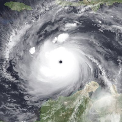
Even as her CDO is becoming more and more asymmetrical and ill-defined, #Hurricane #Beryl just refuses to give up as she begins her closest apporach to Jamaica. No, she is trying to wrap another CB around her center in a desperate attempt to fend off shear and dry air. #tropicswx
1
13
48
@Sausius_wx
Sausiuswx
2 years
BREAKING; According to the newest JTWC fix #Noru ( #KardingPH ) is now an extrenely dangerous Super #Typhoon with 1 minute sustained wind-speeds of 240 km/h (150 mph) and a MSLP of 932 mbar. Further intensification is possible before it makes landfall in northern Luzon. #tropicswx
Tweet media one
Tweet media two
Tweet media three
Tweet media four
0
14
44
@Sausius_wx
Sausiuswx
1 year
Super #yphoon #Mawar is such a beautfiful looking storm at the moment. The eye, the mosovortices, the ouztflow, the gravity waves, just everything. #tropicswx
1
10
47
@Sausius_wx
Sausiuswx
6 months
Here are a few more shots from what i can now officially call a tornadic #supercell that we intercepted near Béthune, France on Monday. It's very much possible that the lowering that can be seen on some of these photos is actually the #tornado . #EUwx
Tweet media one
Tweet media two
Tweet media three
Tweet media four
0
8
44
@Sausius_wx
Sausiuswx
11 months
#StormCiar án has formed a sting. You can clearly see the fillaments at the end of the cloudhead, a tell-tale sign. Doesn't bode well at all for Brittany and Channel islands in Particular. #ciaran #storm #windstorm #Temp ête
Tweet media one
Tweet media two
5
12
42
@Sausius_wx
Sausiuswx
11 months
BREAKING: The ESWD entry for the Lavino, Bulgaria #Tornado from November 4th has also been updated to include a new rating of IF3. This makes it only the third intense (meaning (I)F3+) tornado in Bulgarian history according to Ivanov (2016) and first according to the ESWD. #EUwx
Tweet media one
1
8
44
@Sausius_wx
Sausiuswx
6 months
Here is another retouched video of that lowering in the strong #supercell we intercepted in northern France yesterday. As you can see it was only periodically lit up by lightning, which is why I had to readjust at the beginning. #EUwx
2
13
43
@Sausius_wx
Sausiuswx
4 months
Somewhat unusual sight of a relatively well structured #storm making landfall in the Netherlands towards the middle of June. Tho reminiscent of storm Poly from last year. Winds in Zeeland gusting to about 90-100 km/h right now according to main network data. #windstorm #EUwx
Tweet media one
Tweet media two
2
15
43
@Sausius_wx
Sausiuswx
1 year
NWS St. Louis is doing a very good job at explaining the conditionality of tomorrow near warm front severe threat on the cap being broken. That being said the 18Z HRRR does suggest cap breakage and a brief time-frame for intense #tornadoes . #IAwx #MOwx #ILwx #MINwx #severewx
Tweet media one
Tweet media two
Tweet media three
Tweet media four
2
9
41
@Sausius_wx
Sausiuswx
11 months
Precisely at this time 10 years ago the infamous Super #Typhoon #Haiyan reached its official peak intensity (JMA in 10 min mean) of 230 km/h (145 mph) 895 mbar. JMere hours later it would make its devastating landfall in Guiuan, Eastern Samar at peak intensity... (1/x) #wxhistory
1
12
40
@Sausius_wx
Sausiuswx
6 months
Erm, what the heck. I just pulled up the Abu Dhabi airport observed sounding from 12Z and Dubai can propably count itself lucky that it was "only" subjected to the great flood and not also slabbed by a massive #tornado . Unreal sounding for the middle east... #UAEwx #severewx
Tweet media one
0
10
41
@Sausius_wx
Sausiuswx
3 months
The worst case scenario continues to unfold for the southern windward islands as #Beryl shows no signs of stopping its period of rapid intensificaiton. In fact with deep convection now fully surrounding the core it should only tned to hasten the rate of intensification #tropicswx
Tweet media one
1
5
40
@Sausius_wx
Sausiuswx
5 months
Believe me, I am not saying this lightly. Today seems like one of the most menacing setups I have ever seen in my 3+ years of tracking. The parameter space across Oklahoma in particular is insane for sinificant #severewx including intense loong-tracked #tornadoes . #OKwx #KSwx
Tweet media one
Tweet media two
Tweet media three
Tweet media four
0
9
40
@Sausius_wx
Sausiuswx
11 months
ECMWF with the first proper #freeze for all of central Europe next week, which is something I don't particularly look forward to On the brighter side, #winterwx enthusiasts all over could have varying chances to be delighted by #snow (more on that in later posts). #EUwx
Tweet media one
Tweet media two
Tweet media three
Tweet media four
0
7
37
@Sausius_wx
Sausiuswx
6 months
In this shot of the amazing #Supercell thunderstorm we intercepted near Béthune, France yesterday, you can clearly see some sort of lowering in the meso. #EUwx #orage
Tweet media one
0
9
38
@Sausius_wx
Sausiuswx
3 months
Who gave the Euro the GFS's booze??? #tropicswx
Tweet media one
0
4
37
@Sausius_wx
Sausiuswx
1 year
I have to say it all went a bit quicker then I expected but according to the latest JTWC fix for 18Z #Mawar is once again a Super #Typhoon with 1 min sustained winds of 240 km/h (150 mph) & a MSLP of 930 mbar. Thankfully it is leaving Guam behind now. #TyphoonMawar #tropicswx
2
8
38
@Sausius_wx
Sausiuswx
3 months
German Weather Service has issued effectively a severe thunderstorm watch for parts of west-central Germany. Warning of the potential for (extremely) severe thunderstorms in the form of #supercells with damaging wind #gusts , large #hail and perhap a #tornado or two tomorrow #EUwx
Tweet media one
1
15
36
@Sausius_wx
Sausiuswx
1 year
@agro__sol @NWSSPC fearmonger this ratio🤡
0
0
36
@Sausius_wx
Sausiuswx
1 year
Not only does #Ilsa continue to have lots of eyewall lightning but it has only been increasing lately. This strongly suggests continued, perhaps even accelerating, rapid intensification. #tropicswx #cyclone
1
8
36
@Sausius_wx
Sausiuswx
2 years
Getting several reports, some by local media, that there has just been significant severe #weather in southern #brazil around the city of Canoas. Likely had a #tornado as well and this scenario seems plausible based on GFS forecast soundings from the area. #wx
Tweet media one
Tweet media two
@jornalnh
Jornal NH
2 years
TEMPORAL ⛈️ Em Canoas, árvores caídas e prédios destelhados pela força dos ventos. Pontos do município estão sem energia elétrica. Vídeo: Juliano Piasentin/GES-Especial
1
25
144
2
13
35
@Sausius_wx
Sausiuswx
3 months
The National hurricane center has labelled #Invest96L , which could also become a #hurricane and follow a similar track for Beryl. #tropicswx
Tweet media one
Tweet media two
2
8
37
@Sausius_wx
Sausiuswx
2 years
The 18Z KLIX special sounding is highly concerning. Most notably because it shows a whopping 193 J/KG of 3CAPE, a very high value. Also steep low-level lapse rates, almost 300 m2s2 of 0-1 km SRH, plenty of streamwise vort and good critical angle. #severewx #LAwx #MSwx #ALwx
Tweet media one
0
17
36
@Sausius_wx
Sausiuswx
7 months
#Cyclone #Djoungou has definitely reached and passed its prime by now. As it begins to get swept up by the westerlies shear will now begin to rapidly increase. While jet interaction remains favourable for now it can't offset both this AND the waning energy supply. #tropicswx
0
7
36
@Sausius_wx
Sausiuswx
7 months
Is it particularly organised at all? Absolutely not! But is it a (sub)tropical #cyclonein the South Atlantic? Hell yes and that is noteworthy enough in and of itself. #01Q is its designation and it should undergo some further development over the next few days. #tropicswx #BRwx
2
9
34
@Sausius_wx
Sausiuswx
1 year
Super #Typhoon #Mawar has once again turned into a true beast clocking in at 280 km/h (175 mph) but has now likely just about reached its secondary peak. Recently the CDO has become a tad more asymmetrical and there are signs that another eyewall replacement is brewing #tropicswx
3
10
34
@Sausius_wx
Sausiuswx
6 months
The 12Z observed sounding from Norderney shows excactly the kind of kinematics we feared. 0-3 km SRH is over 300 m2s2, more then twice the 90th percentile for SigTor cases in Europe. If we can get some instability going, which seems likely, a strong #tornado seems possible. #EUwx
Tweet media one
2
5
36
@Sausius_wx
Sausiuswx
1 year
Looks like #Poly thinks it is a subtropical #storm , Borkum radar shows what looks like a rainband wrapping into an eywall. Latent heat release may play a role in enhancing the storm but this obviously isn't actually a subtropical storm #windstorm #EUwx
Tweet media one
1
8
35
@Sausius_wx
Sausiuswx
3 months
Thankfully, #Hurricane #Beryl fell off again on final approach to Yucatan. For a time, it looked like the worst case scenario (major) for areas around Tulum and Cozumel would happen. That's not the case. It's still a dangerous storm for those areas tho. #tropicswx
4
9
34
@Sausius_wx
Sausiuswx
1 year
Unfortunately #Hurricane #Idalia is really starting to crank now. An eye-feature is beginning to show up on visible imagery as impressive convective bursts continue. Lightning activity now picking up as well, just within the last hour. Really not looking good at all... #tropicswx
0
8
34
@Sausius_wx
Sausiuswx
1 year
Here is a picture of some of the #hail that fell with the dangerous #supercell near Kassel a while back. These are reported as golf ball size or 5 cm and that seems about right, Cell has now become outflow dominant and turned into a bow echo. #unwetter #severewx
Tweet media one
2
11
35
@Sausius_wx
Sausiuswx
25 days
Overnight #Yagi seemed a bit sick after it had previously briefly peaked as a rare Super #Typhoon in the South China sea. This was due a (propably failed) eyewall replacement cycle. Now Yagi is recovering quite well it seems, tho a new cycle may be looming. #tropicswx
0
7
34
@Sausius_wx
Sausiuswx
3 months
The worst case scenario for the southern Windward islands is unfolding as Major #Hurricane #Beryl seems in better shape then ever after its eyewall replacement and recon indicates its making a run at category 5 Intensity as it approaches the islands. #tropicswx
0
6
34
@Sausius_wx
Sausiuswx
1 year
The effects of dry air entrainment and upwelling due to slow movement, coupled with the generally more stable environment are now getting to #Typhoon #Mawar . JTWC still has it as a 100 kts C3 for now but we have now reached the point of more rapid weakening it seems. #tropicswx
1
9
31
@Sausius_wx
Sausiuswx
8 months
#Norway MET has now issued the highest possible warning level (red) for #Storm " #Ingunn "expected to hit tomorrow. Red warning means extreme weather and essentually danger to life (similar to UK). Hurricane-force #wind gusts up to 180 km/h can be expected in that area. #Euwx
Tweet media one
Tweet media two
1
17
34
@Sausius_wx
Sausiuswx
3 months
Recon is already finding evidence that #Hurricane #Beryl is still a category 4, well above most objective and subjextive fixes. 750 mbar FL winds of 134 kts and Non-suspect SFMRs of at least 121 knots. Thank God we have recon in the Atlantic. #tropicswx
Tweet media one
Tweet media two
1
8
34
@Sausius_wx
Sausiuswx
3 months
#Beryl continues its unrelenting assault on the record books with this astounding run at category 5 intensity. This structure is just surreal for what's virtually still June, the eye's a crisp 21°C and the intense eyewall lightning just doesn't stop. What a storm! #tropicswx
1
6
32
@Sausius_wx
Sausiuswx
11 months
A station in Pointe du Roc, Normandy (not quite sure which kind) recorded a wind gust of 166 km/h (103 mph) from #StormCiaran . A WMO station in Pointe du Raz, Brittany has recorded a peak gust of 141 km/h (88 mph) with a sustained wind of 105 km/h (65 mph) last hour. #Ciaran
Tweet media one
2
14
31
@Sausius_wx
Sausiuswx
1 year
Structure of #storm #Poly still pretty impressive on radar from Den Helder, Still can't quite believe I am seeing this in JULY! Dangerous winds of 100-130 km/h, up to 150 km/h near the coast, will spread into Friesland and Groningen over the next few hours. #windstorm #wind
Tweet media one
0
7
33
@Sausius_wx
Sausiuswx
3 months
Interestingly compared with recon based NHC fixes for #Beryl , Satellite surface wind analysis currently outperforms all IR and MW based methods (even if only slightly in case of D-MINT), including Satcon. ADT/AiDT and D-PRINT are well off the mark with only ~100 knots. #tropicswx
Tweet media one
Tweet media two
Tweet media three
Tweet media four
2
6
32
@Sausius_wx
Sausiuswx
26 days
Yeah that was indeed lift off nothing stopping the CBs from wrapping around the centre this time and an eye has formed. Banding is also becoming ever better defined. Two things are clear: #Yagi ( #EntengPH ) is rapidly intensifying and it is propably a typhoon now. #tropicswx
@Sausius_wx
Sausiuswx
27 days
This might be lift-off for #Yagi ( #EntengPH ). Convective bursts are rotating around the center more convincingly then ever. SSMIS images shows well defined banding wrapping into a nascent eyewall. Core formation lays the groundwork for rapid intensification. #tropicswx
0
5
19
2
7
32
@Sausius_wx
Sausiuswx
11 months
Massive #tornado in Paraguay a short while ago. Note that the this GFS sounding propably is underdoing the environment but even here you can see copious amounts of SRH and lots of inflow height. For south america on the GFS, that'll do it. #PRwx #tormenta #severewx
Tweet media one
@AnthonyPaez595
AMPY. 🇵🇾⛈📷
11 months
#Hoy | Tornado en Río Negro, Mbokajaty del Yhaguy, departamento de Cordillera. 😱🌪️🇵🇾 Video gentileza de nuestros colaboradores
47
528
2K
2
8
31
@Sausius_wx
Sausiuswx
4 months
Wakey Wakey, the WAPC is back as #Invest93W now has a tropical #Cyclone formation alert from JTWC. The system could come quite close to the Phillipines over the weekend but deterministic models currently do not plot a direct landfall. #tropicswx
1
7
32
@Sausius_wx
Sausiuswx
1 year
The fact that models are in consensus on a significant #windstorm over the north sea in July still feels surreal to me. DWD doing so much as mentioning a sting jet is crazy. Dangerous situation brewing tomorrow in N #Netherlands and NW #Germany . #storm #sturm #unwetter
Tweet media one
Tweet media two
Tweet media three
Tweet media four
0
15
31
@Sausius_wx
Sausiuswx
1 year
With the eye of #Cyclone #Mocha clearing out yet again, I would say it's likely that it is (again) a category 5 on the SSHWS. Latest PGTW fix is still T7.0 and estimates from OPEN-AIIR and DMN (based on the most recent AMSR2 image) are 138 kts and 141 kts respectively. #tropicswx
0
7
30
@Sausius_wx
Sausiuswx
4 months
Large #tornado strikes town in SA SA Weather service calls it a "wedge tornado" in an official publication BBC be like: Tornado-like storm hits south africa town🤡 I am sorry but this is just poor journalism right here #SAwx #wxtwitter
Tweet media one
Tweet media two
6
3
32
@Sausius_wx
Sausiuswx
1 year
BREAKING: The BOM has finally named Tropical #Cyclone #18S as #Ilsa . This comes as a blossoming convective burst is enveloping the LLC, likely in response to improving shear & increasing Oceanic potential. BOM forecasts an eventual C4 (AUS) landfall near Wallal Downs. #tropicswx
0
8
31
@Sausius_wx
Sausiuswx
3 months
Concering wording from the DWD regarding tomorrows #severewx event in Germany. Mentioning the possibility of #hail up to 5 cm, damaging #wind gusts and especially further west #tornadoes . Also mentioning possibility for "extremely severe" (warning Level 4/4) #thunderstorms . #EUwx
Tweet media one
Tweet media two
2
5
32
@Sausius_wx
Sausiuswx
1 month
#Hurricane #Ernesto is really looking better than it ever has and is probably in the best environment cumulatively that it ever has been. It's probably more like 75 knots than 65 knots with that CB wrapping around the center. #tropicswx
1
9
31
@Sausius_wx
Sausiuswx
2 months
I am growing more and more concerned by the day about the potential for serious flash #flooding with #thunderstorms in NW Germany on Tuesday. Very high if not extreme CAPE, very high PWAT and slow storm motion. All the ingredients are there. #EUwx
0
10
31
@Sausius_wx
Sausiuswx
1 month
You know what? #Hone may currently be in a more favourable environment for supercells then for Tropical Cyclones. CAPE is >2000 J/KG and 200-850 mbar shear is >50 knots. And it shows because on satellite the convection seems to currently consist of 1 #supercell . #tropicswx
4
5
31
@Sausius_wx
Sausiuswx
2 years
Incredibly, while a general consensus for a Mozambique landfall of #Cyclone #Freddy has emerged, various ensemble members still have other plans, that would see it stick around for longer. Even the operational GFS is still sticking to another comeback. Can you imagine? #tropicswx
Tweet media one
Tweet media two
Tweet media three
Tweet media four
1
7
31
@Sausius_wx
Sausiuswx
9 months
#Belal has decided to put on a show during its final approach to Réunion. Aided by the diurnal cycle a vigarous burst of deep convection has fired up around the center. MFR still believes that it'll make it to Intense Tropical #Cyclone before landfall and it's clearly trying.
0
11
30
@Sausius_wx
Sausiuswx
1 year
@agro__sol @NWSSPC You know what won't be an overhyped bust? This ratio🤡
0
0
30
@Sausius_wx
Sausiuswx
1 year
#Cyclone #Mocha is now rapidly falling apart as it advances inland over the rugged terrain of central Myanmar. Heavy #rain is however likely continueing in many places, especially with the banding on the south side, exacerbating already severe #flooding .
0
9
30
@Sausius_wx
Sausiuswx
1 year
#Cyclone #Mocha is now almost surely a major cyclone (C3 SSHWS) and and still rapidly strengtheing. Doesn't seem like shear is coming to save the day either at the moment. Extremely bad situation for #Myanmar & SE #Bangledesh and landfall could very well be catastrophic
1
8
29
@Sausius_wx
Sausiuswx
1 year
Time to talk about Tuesday: Synoptically a very favorable setup, indicating that an high-end all hazards ( #wind , #hail and (strong) #tornadoes ) #severewx event is likely. There is virtually no doubt that favorable kinematics will overspread a large wide open warm sector. (1/2)
Tweet media one
Tweet media two
Tweet media three
Tweet media four
3
6
29
@Sausius_wx
Sausiuswx
2 years
According to the latest JTWC Intensity fix, which was just realeased via the ATCF, #Freddy is now a major hurricane-equivelent #Cyclone with 1 minute sustained winds of 185 km/h (115 mph). Although this comes right as its apperaerence begins to deterioate again. #tropicswx
1
5
30
@Sausius_wx
Sausiuswx
1 year
Wow, just wow! Even several hours after landfall, the structure of #Cyclone #Ilsa is still fully intact and that of a mature high-end tropical cyclone. Formative banding can still be seen wrapping into a highly defined, very symmetrical CDO. #tropicswx
Tweet media one
Tweet media two
Tweet media three
Tweet media four
0
5
28
@Sausius_wx
Sausiuswx
3 months
Look who is back! Its our friend(?) the eye of #Hurricane #Beryl , well sort off. Certainly some dramatic improvement in cloud pattern. This is propably testament to Beryl now having emerged from the worst of the shear and still being over very high OHC waters. #tropicswx
0
9
30
@Sausius_wx
Sausiuswx
2 years
According to both objective estimates from ADT and subjective estimates from PGTW, #Hinnamnor is now once again a category 5 on the SSHWS as both yield a T/CI Number of 7.0. This makes it likely that the JTWC will follow suit in the 00Z ATCF update #tropicswx #wx
Tweet media one
Tweet media two
Tweet media three
Tweet media four
0
7
29
@Sausius_wx
Sausiuswx
2 months
#Typhoon ( #05W ) #Gaemi has completed its eyewall replacement cycle by way of a merger and is now in better shape then ever. Taiwanese radar is showing a fierce, well defined and thick eyewall as a result. Not the kind of image you wanna see with imminent landfall. #tropicswx
Tweet media one
2
9
30
@Sausius_wx
Sausiuswx
1 year
After a brief period of soulsearching, I think it is fairly safe to say that #Ilsa has now firmly begun to rapidly intensify as cirrus-level outflow expands into 3/4 quandrants and increasingly defined banding is wrapping into a more and more symmetrical CDO. #tropicswx
0
8
30
@Sausius_wx
Sausiuswx
5 months
Tomorrow is looking incrasingly more potent actually. Confidence is increasing in a corridor for discrete #supercells potentially capable of all #severewx hazards, yes even #tornadoes , across central France tomorrow afternoon and (early evening). Source:
Tweet media one
Tweet media two
Tweet media three
0
5
30
@Sausius_wx
Sausiuswx
11 months
Increasingly looks like we are gonna get at least one more #cyclone in this #Hurricane season. GEFS signal is even stronger then this shown on the EPS. Should stay confined to the eastern Carribean tho before a trough scoops it up. #tropicswx
Tweet media one
Tweet media two
Tweet media three
Tweet media four
1
8
30
@Sausius_wx
Sausiuswx
5 months
Very bad situation for Dickson, which is approached by another tornadic circulation after having already been hit by an intense #tornado . Similar thing happened to Sulphur already, which is now getting flooded. Worst case scenario for Sulphur in particular. #OKwx
Tweet media one
1
11
29
@Sausius_wx
Sausiuswx
1 year
#Mawar has recently been dethroned from being a Super #Typhoon . A hole has appeared in the CDO and the eye is cooling/becoming increasingly cloud filled. Recent AMSR2 image still seems to show some debris from the old eyewall & overall less impressive structure. #tropicswx
1
4
27
@Sausius_wx
Sausiuswx
3 months
Recent GMI color 89 Ghz coloe composite image of Major #Hurricane #Beryl shows that a pronounced weakness as developed in the SW eyewall and convection has become lopsided to the NE. This is the result of the unfavourable shear which is beginning to take its toll. #tropicswx
Tweet media one
1
7
29
@Sausius_wx
Sausiuswx
2 years
I am quite simply stunned, the Phillipine sea effect has struck agian. #Typhoon #Noru ( #KardingPH ) has continued to explosively intensify and is now in my opinion at least a category 3 on the SSHWS, on the cusp of Being a C4. It doesn't seem to be done either,,, #tropicswx
0
6
27
@Sausius_wx
Sausiuswx
3 months
Respekt an die Person in Kirchhain die einfach diese beiden hammer Blitzfotos heute Nachmittag gemacht hat. #Gewitter Bro kudos to whoever made both of these two lightning photos in Kirchain. #Thunderstorm #EUwx
Tweet media one
@Sausius_wx
Sausiuswx
3 months
WarnWetter Bild des Tages bisher von diesem Blitz in Kirchhain, Hessen. #Gewitter WarnWetter image of the day so far is this lightning shot from Kirchhain, Hesse upon passage og what was at the time a disintegrateing MCV. #thunderstorm #EUwx
Tweet media one
0
0
4
1
4
29
@Sausius_wx
Sausiuswx
1 year
Textbook tornadic #supercell near Auch and Montauban in France a little bit ago. Likely that ths produced large to very #large hail. Now it is a shadow of its former self. Animation from Meteologix based on data from Meteo-France: #orages #severewx
0
7
29
@Sausius_wx
Sausiuswx
3 months
The NHC has gone ahead and marked the tropical wave i mentioned yesterday for a small chance of development as it appraoches the Yucatan later this week. ECMWF ensemble indicates it could actually form into a tropical depression or weak tropical #storm even earlier. #tropicswx
0
5
29
@Sausius_wx
Sausiuswx
8 months
Looks like shear has litterally blown out the deep convection of Tropical #Cyclone #Nat like a candle. No wonder as by shear is over 40 knots acros at least part of the systerm. He ain't gonna last much longer, I can tell you that much. #tropicswx
0
9
29
@Sausius_wx
Sausiuswx
3 months
SSMIS image from a few hours ago appears to show a moat going most of hte way around the core of #Hurricane #Beryl but the resolution is too low to be 100% sure. But if this the case an Eyewall replacement is imminent. Will recon get there in time? #tropicswx
Tweet media one
4
3
28
@Sausius_wx
Sausiuswx
8 months
#Djoungou is now a major Hurricane equivelent #cyclone accprding to JTWC. There is still more room for strengthening even tho shear has begun to increase and JTWC is forecasting a 120 kt peak now. #tropicswx
2
8
27
@Sausius_wx
Sausiuswx
2 years
Very bad situation unfolding in Mozambiqu, as #Freddy is creeping on-shore near Quelimane, where it is making landfall as a near majpr hurricane-equivalent #Cyclone . Truly horrendous #rain totals are likely,as the system virtually stalls inland. Major #flooding guaranteed!
0
7
28
@Sausius_wx
Sausiuswx
11 months
#Otis saw Hamoon and decided it wanted to be like that, so it decided to become a jumpscare major #hurricane . Only this time the reason isn't jet interaction, its just high oceanic potential. Anyway Otis is forecast to make landfall as category 4 within 12 hours. #tropicwx
1
3
27
@Sausius_wx
Sausiuswx
3 months
In the end it was propably just land interaction as the eye of major #hurricane #Beryl has circularised again. Conditions should generalyl be sufficient for Beryl to at least maintain intensity for another 12-24 hours but an eyewall replacement still looms. #tropicswx
0
5
27